Resilient Connecticut: Flooding, Heat Adaptation, and Resilience


Fuss & O’Neill developed resilience and adaptation strategies and conceptual solutions for flooding and heat impacts in several Connecticut communities, including: Fair Haven neighborhood (New Haven), Downtown Danbury, Meadow Street (Branford), and the Mystic section of Stonington. The projects were part of the Phase III of Resilient Connecticut, which is led by the Connecticut Institute for Resilience and Climate Adaptation (CIRCA). The purpose of Resilient Connecticut is to establish resilient communities throughout the state by piloting adaptation strategies and concept designs for resilience. Fuss & O’Neill’s work included assessment and modeling of drainage, riverine, and coastal flooding; development and modeling of alternative solutions to mitigate flooding and heat impacts; development of conceptual designs; and benefit cost analysis.
These projects include significant community engagement with the municipalities, neighborhood groups, and other stakeholders to help shape the project recommendations and conceptual designs. These projects also position communities to leverage additional state and federal funding for final design, permitting, and construction.
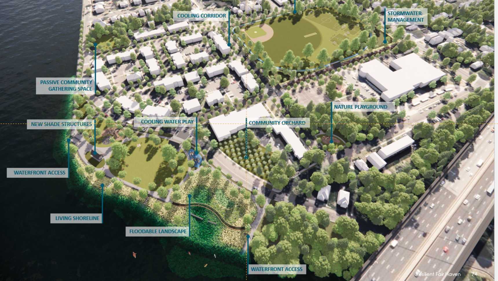
The Fair Haven neighborhood, which is located on a peninsula bounded by the Mill and Quinnipiac Rivers, is vulnerable to flooding from coastal storm surge, high tides, sea level rise, and heavy rainfall events.
The neighborhood is also vulnerable to extreme heat due to high social vulnerability within the community, combined with dense housing, high impervious cover, disconnected green spaces, and long distances to potential cooling centers and/or shelters. These conditions will only worsen, as a warmer and wetter climate will result in greater rainfall intensity and sea level rise, which will exacerbate coastal and drainage flooding.
The Resilient Fair Haven project builds on prior planning and assessment of flood and extreme heat vulnerabilities by CIRCA that were completed as part of Phases I and II of Resilient Connecticut. This project focuses on developing adaptation strategies to mitigate current and future climate-induced flooding impacts to community assets and transportation corridors in Fair Haven, as well as developing strategies to help mitigate the impacts of extreme heat for community residents.
Flooding in the Fair Haven neighborhood threatens public safety and impedes access to critical lifelines and evacuation routes during storms.
Resilient Danbury is focused on developing adaptation strategies and implementable project concepts to mitigate the impacts of current and future climate-induced flooding to key community assets, while also helping to mitigate the impacts of extreme heat.
The project focus neighborhood in downtown Danbury has endured decades of flooding caused by aged, undersized drainage systems directed to a watercourse called “East Ditch” that is constrained within an underground culvert. Existing pipes and culverts cannot handle the volume of water generated during severe storms over the large, highly impervious urban catchment area. The current flooding presents public safety challenges to residents of the City, leading to closures of Main Street in front of a community health center where patients have been previously trapped by flooding events. The risks associated with this flooding continue to increase as more frequent and severe precipitation events occur due to climate change.
Downtown Danbury is also vulnerable to extreme heat due to the combination of physical conditions including substantial impervious cover and disconnected green space, as well as lack of capacity in existing cooling centers. The vulnerability due to physical conditions exacerbates the risk to members of the community with high social vulnerability.
The Meadow Street neighborhood in Branford is located along the Branford River. Flooding of this neighborhood occurs when the river, a tidally-influenced estuary, overtops its banks during coastal storm events. Businesses in the neighborhood are impacted by the damage caused by flooding, as well as by the operational disruption and lack of access to their properties due to flooding. In addition to local residents and businesses that participated in community engagement associated with the project, Amtrak, which has a rail line within the project area, was a stakeholder with unique needs and priorities.
Fuss & O’Neill identified a range of flood adaptation options and evaluated project benefits, including a benefit cost analysis, potential state and federal funding sources, stakeholder input, and possible barriers to implementation. Based on the analysis, the alternative identified for implementation was the installation of a flood gate with berms that would tie into the existing elevated Amtrak rail embankment. This is a substantially lower cost alternative that innovatively leverages the flood protection that is unintentionally provided by the rail embankment.
Downtown Mystic, which contains numerous historic and cultural assets that are the foundation for a robust tourism-oriented economy, is at high risk for extreme coastal flooding from both storm surge and increased rainfall. Mystic’s coastal neighborhood includes a complicated mix of land uses and is home to a range of stakeholders.
Fuss & O’Neill is providing resilience planning and engineering services to identify climate adaptation options and conceptual designs to address coastal flooding and extreme heat.
Adaptation strategies are expected to include relocation or protection of historic resources, protection of critical facilities and the passenger rail station, and enhancement of connections from critical facilities to the greater Stonington community and nearby Groton. Options for extreme heat management will also be evaluated (e.g., green infrastructure, cooling centers, and resilient/cooling corridors). Fuss & O’Neill is performing a vulnerability assessment of roads, regional assets, historic resources, and critical facilities using available mapping and coastal flood risk modeling scenarios for existing and future coastal flood events.
This project includes a robust stakeholder engagement process through the formation of a Citizen and Technical Advisory Committee and an intensive multi-day charrette process to directly engage the community and decision-makers. This stakeholder engagement will build collaborative partnerships among various group and will ensure that the solutions do not compromise the region’s capacity to drive a multi-million-dollar tourism economy.